


2020_03_14 cap de Carmil

albaultjl
User
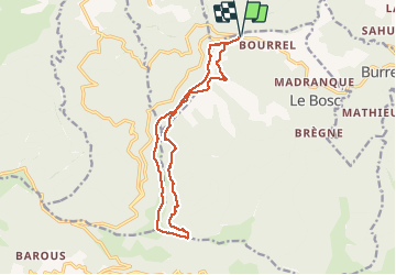

Length
15.4 km

Max alt
1617 m

Uphill gradient
701 m
Km-Effort
25 km

Min alt
997 m

Downhill gradient
701 m
Boucle
Yes
Creation date :
2020-03-14 07:58:52.542
Updated on :
2020-03-14 13:36:15.326
5h36
Difficulty : Medium

FREE GPS app for hiking
 SityTrail
IGN / Geographical institutes
SityTrail Plus
The world is yours!
About
Trail Walking of 15.4 km to be discovered at Occitania, Ariège, Le Bosc. This trail is proposed by albaultjl.
Positioning
Country:
France
Region :
Occitania
Department/Province :
Ariège
Municipality :
Le Bosc
Location:
Unknown
Start:(Dec)
Start:(UTM)
372497 ; 4757748 (31T) N.
Comments